
How Ice Age Floods Shaped the Northwest (and Hermiston)
3/26/2008
HistoryLink.org Essay 8449
The sound of the great Ice Age floods would have been terrifying: some 530 cubic miles of water bursting through a wall of ice more than 2,000 feet high; roaring over Eastern Washington at speeds of up to 80 miles an hour; drilling deep crevices into ancient basalt, stripping away topsoil in some areas, piling it up in others, flinging boulders around like ping pong balls. The pressure on the earth’s crust probably triggered earthquakes and landslides. The floodwaters pounded down the Columbia Gorge and into the Pacific with enough force to dig channels into the ocean floor. Then a new ice dam formed, impounded more water, and eventually collapsed, unleashing new floods, in a process that was repeated again and again until finally, about 13,000 years ago, the most monumental cycle of hydraulic engineering on earth came to an end.
Pummeled by “Megafloods”
The very size of the floods made it difficult to recognize their impact. Iconoclastic geologist J Harlen Bretz (a former Seattle high school science teacher) first proposed in 1923 that the arid “scablands” of Eastern Washington had been carved out by a rapid, massive flood — not, as most of his contemporaries believed, by the ordinary processes of erosion by wind and water, over millions of years.
His ideas were ridiculed for decades. Aerial photographs in the 1950s vindicated Bretz to some degree by revealing the outlines of flood features that were too large to be easily identified from the ground. But it was not until the 1970s that satellite photos, taken from a vantage point 570 miles overhead, provided enough of a perspective to convince the last of the skeptics.
Even Bretz underestimated the scale and frequency of the floods. Geologists now believe that the Northwest was pummeled by a hundred or more “megafloods” during the last Ice Age alone, beginning about 20,000 years ago. There were at least a dozen earlier periods of major glaciation, stretching back for 2 million years, and flooding may have occurred during each of them.
The primary source of the more recent floods was Glacial Lake Missoula, a huge inland sea created when a lobe of the Cordilleran Ice Sheet crept south from Canada and blocked the drainage of the Clark Fork River in Idaho. Water backed up behind the dam into western Montana, eventually covering some 3,000 square miles of land to a depth of up to 2,000 feet.
Ice makes a flimsy dam. Studies of ice-jammed lakes in Alaska and elsewhere have shown that when the level of water behind an ice dam reaches a certain point, the ice floats, allowing water to escape from underneath, first in a trickle, then in a torrent. That’s one explanation for the failure of the dam holding back Lake Missoula. Another is that highly pressurized water at the base of the dam permeated cracks in the ice. The cracks widened into tunnels at an exponential rate, and the dam caved in on itself.
Once the dam was breached, Lake Missoula was uncorked as explosively as a bottle of fiercely shaken champagne. An estimated two trillion tons of muddy, ice-laden water — a volume equal to 10 times the combined flow of all the rivers in the world today — tore through the remnants of the dam and thundered over parts of four states on a 630-mile journey to the sea. The lake drained in two or three days. Almost as soon as it was emptied, ice blocked its outlet again and the lake began refilling, in a cycle believed to have been repeated every few dozen years or so.
The Pacific Northwest, Rearranged
The Ice Age floods rearranged the dirt, rocks, streambeds, and contours of 16,000 square miles of the Pacific Northwest. They pared land down to bedrock in places, built it up in others; rerouted rivers; scoured out coulees and potholes; and steepened and widened the Columbia Gorge. Enormous boulders, encased in ice, bobbed along on the floodwaters, ending up on hills and in flatlands hundreds of miles from their origins, a puzzle for the farmers who would someday plow around them.
Temporary lakes formed behind natural constrictions along the course of the Lower Columbia River at Wallula Gap, Rowena Gap, and Kalama. Flood-borne sediments settled out of those lakes, becoming part of the rich topsoil that supports the farms and orchards of Yakima, Walla Walla, and the Willamette Valley today.
The sediment is also the basis for the quality of wines produced in the Mid-Columbia Basin. Wine grapes require soil that is both fast-draining and water-retentive, characteristics provided by the fine-grained sand and silt in the flood deposits. Wheat grows tall in the areas of the Palouse that the floods skipped over, leaving intact the deep layers of windblown silt and soil that once covered most of the Plateau.
Thousands of years after the last drop drained away, the geologic legacy of the floods continues to define the Northwest, from the way the land looks to the uses humans have found for it. The following tour of the state explores the impact of the Ice Age floods on Washington. It was written and curated by HistoryLink senior historian Cassandra Tate. Geologist Bruce Bjornstad, author of On the Trail of the Ice Age Floods, served as guide and technical advisor.
Palouse Falls
The Palouse River fits the cataract at Palouse Falls and the massive canyon beyond it as well as the foot of a small boy fits into a size ten shoe. The semicircular plunge pool at the bottom of the falls is absurdly large for the relatively thin thread of water that drops into it. The modern river is too puny to have chewed into the edge of the falls and left the old pool behind. Nor does the river have the hydraulic muscle to have eroded the valley that carries it to the falls or the deep canyon below, with its maze of coulees, abandoned spillways, and serrated buttes. The brunt of this work was done thousands of years ago by Ice Age floods. As geologist Bruce Bjornstad puts it, “The canyon has little to do with the Palouse River and everything to do with the floods.”
The river once ran west through Washtucna Coulee on its way to join the Columbia in the Pasco Basin. Floodwaters racing down from the scablands overfilled the coulee and surged across the Palouse-Snake River Divide, creating a shortcut to the Snake. The Palouse River still uses this flood-carved shortcut. Turning abruptly to the south just past Hooper, it drops over a 198-foot cliff and then flows 11 miles to the Snake. Geologists believe that the earliest of the Ice Age floods plunged directly into the Snake. Successive floods eroded the lip of the original waterfall, forcing it to migrate upstream to its present position. The Palouse River Canyon is the result of that retreat.
Floodwaters rammed into the Snake with enough force to reverse its flow, backing it upstream for more than 100 miles, to Lewiston, Idaho, and beyond. These “backwards floods” heaped gravel into bars several hundred feet high and two to three miles long, at intervals all along the Snake and into the valley of the Clearwater River. One of the largest of the bars is located at the mouth of the Palouse River Canyon, near Lyons Ferry Park (formerly a state park, now privately managed). Nearly a half-mile wide, it fills more than half the width of the Snake River Valley floor.
The floods skipped most of the Palouse Prairie in Eastern Washington and north central Idaho, leaving in place ancient deposits of windblown sand and silt called “loess.” Layers of loess, up to 250 feet deep, are the basis for the rolling hills and fertile topsoil that characterize the Palouse. Known as “hills of gold,” they have made the region one of the most productive agricultural areas in the world.
Wallula Gap
Within hours after breaking through the ice dam in Idaho, the contents of Glacial Lake Missoula began to converge at Wallula Gap, an opening cut by the Columbia River through the Horse Heaven Hills near Pasco. The gap — the only outlet to the sea for water draining from the Columbia Plateau — is about two miles wide. Two miles is more than wide enough for normal flows, but not for an Ice Age flood. When the ice dam failed, some 530 cubic miles of water rushed toward a chute that could discharge no more than 40 cubic miles a day. The result was a bottleneck that has been compared to a dime-sized drain at the bottom of a very large hot tub: the plug may be pulled, but the water still takes a while to trickle out.
Water backed up for more than 2,000 square miles behind Wallula Gap, creating a temporary lake called Lake Lewis. The lake stretched west into the Yakima Valley, east into the Walla Walla Valley, and north into the Quincy Basin. The maximum depth was 1,200 feet, enough to turn several large hills into what seemed to be islands, poking out of the water like whales at rest. The present day site of the Tri-Cities was buried under more than 900 feet of water; the backwaters were 250 feet deep at Yakima and Walla Walla. It took nearly a week for all the water to drain and the ephemeral, intermittent lake to disappear.
Left behind were layers of fine-grained sediment that have proven to be ideal for the production of wine grapes. Ninety percent of the vineyards in Washington state are planted in areas that have been blanketed by sand and silt deposited during Ice Age floods. The most prolific and renowned regions are those that were once at the bottom of Lake Lewis.
Lake Lewis also provided important clues about the total number of floods. In 1926, an irrigation ditch went out of control and cut a deep ravine, known as Burlingame Canyon, near Walla Walla. Some 50 years later, geologist Richard Waitt noticed that the ravine had exposed sedimentary deposits called “rhythmites,” composed of sand and silt laid down by successive flood pulses. Geologists have counted 40 separate layers here, leading to the conclusion that the lake filled and drained at least that many times.
Columbia River Gorge
Ice Age floodwaters accelerated in places where the flow was constricted and slowed where they could spread out, just like the stream from an ordinary garden hose when the nozzle is tightened or loosened. They boomed through the long, narrow chute of the Columbia Gorge at speeds approaching 80 miles an hour. The canyon walls, which had sloped gently down to the river before the floods, were planed to almost vertical surfaces. Many tributary streams on the south (Oregon) rim were left hanging, creating the waterfalls and cascades that thread that side of the Gorge today. Walls on the north (Washington) rim were over-steepened, making them vulnerable to landslides.
The result is a place of such surpassing beauty that Congress designated it the nation’s first National Scenic Area, in 1986. With its flood-scoured walls and sleek waterfalls, the Gorge inspires visitors to reach for adjectives: awesome; spectacular; breathtaking.
The Gorge is the only passageway through the Cascade Mountains for water draining from the entire Columbia Basin. It is about 90 miles long (extending from Maryhill almost to Vancouver), as deep as 4,000 feet in places, and varies in width from one and a half to three miles. The Columbia River made the initial cut. The floods chiseled out the rest. Floodwaters as deep as 900 feet tore through the Gorge with ferocious power. They scrubbed soil from the lower canyon walls, sliced into the bedrock, and swept away huge piles of gravel.
The strong currents also ripped through the flanks of an extinct volcano on the Washington side of the river. The volcano had been composed largely of a kind of rock called andesite, which is high in silica and particularly vulnerable to erosion. “If there were a building code for mountains,” says geologist David Alt, “andesite volcanoes would never pass inspection.” Only the more resistant, 848-foot-high lava core of the volcano remained standing. The explorers Meriwether Lewis and William Clark gave it the name it has today: Beacon Rock.
Pacific Ocean
Echoes of the Ice Age floods can be imagined in the sound of the waves breaking on the beach at Cape Disappointment, like aural footprints lingering in the air. It’s been calculated that the release of some 530 cubic miles of debris-laden water from an elevation of 4,200 feet in Montana down to the sea produced 4,500 megatons of energy: more than 10 times the energy produced by the 1980 eruption of Mount St. Helens. The combined energy of all the floods may have been double that of the impact of the comet that is believed to have wiped out the dinosaurs 65 million years ago. The floodwater — still carrying much of its load of rocks, gravel, topsoil, vegetation, animal carcasses, and ice — would have smashed into the sea on a shock wave of noise.
It took about a week for all the water from Glacial Lake Missoula to reach the sea. At several points along the route, the flow backed up to form temporary lakes behind hydraulic dams, created when water poured in faster upstream than it could drain downstream. The last squeeze came at the Kalama Narrows below the present city of Portland, where the Columbia River channel is a little less than two miles wide. About a third of the flood surge was diverted into the Willamette Valley. Icebergs bobbed along on the spillover, carrying boulders that would end up in fields as far south as Eugene. The ponded water dropped up to 100 feet of nutrient-rich Palouse sediment on the valley floor. “Think of all the barren bedrock in the scablands as you pass the lush fields and the flourishing groves of fruit and nut trees in the Willamette Valley,” says geologist David Alt.
The main flood pulse slammed into the Pacific — which was 300 feet lower than now, and about 50 miles west of the current coastline — with enough violence to plow an underwater trench into the continental shelf. An estimated 600 million cubic yards of debris ended up on the ocean floor. For all the sediment and rocks that settled out of backwaters in the Quincy and Pasco Basins and in the Willamette Valley, the floods still hit the sea with most of their solid material intact.
Licensing: This essay is licensed by HistoryLink.org under a Creative Commons license that encourages reproduction with attribution. Credit should be given to both HistoryLink.org and to the author, and sources must be included with any reproduction.
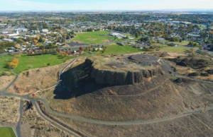
Hermiston Butte Photo Wiki Commons License